![]()
![]()
33
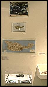
    Satellite Image


taken from 3 miles above Santa Barbara


Geology


    Vegetation Map of Santa Cruz Island, 1980


Map and Imaging Library


    Shaded Relief Map of Santa Cruz Island, 1995


Map and Imaging Library


    Topographical Map of Santa Cruz Island


Geology


    Blue Schist from Santa Cruz Island


Geology


    Thin section of Blue Schist from Santa Cruz Island


Geology


    Staurolite crystals from Santa Cruz Island
Geology
Geologists measure across a greater spatial scale than any other discipline (unless we count cosmologists). Here we examine one site on Santa Cruz Island, from a Landsat photograph down to an electron microscope photograph of a mineral cross-section.Two things that have prompted the development of this dramatic increase in the range of measurement have been new methods of analysis, and new questions regarding the formation of rocks. While in the sixteenth century collectors might just cut and polish rocks in order to appreciate their beauty, now we cross-section them to reveal their structure, and prepare slides of thin sections to examine them under the microscope.